El Niño 2026: what the warnings say about rain, drought and heat at year-end
The event is strong and expected to intensify. Warnings point to above-normal rain in Brazil's South and drought in the North and Northeast, but they do not forecast a continent-wide disaster.
Reviewed by Jackson on Nov 14, 2026. How we work
Quick answer
El Niño, an abnormal warming of part of the equatorial Pacific, is active. Brazil's INMET says it has a high probability of becoming very strong from November. For November 2026 to January 2027, INMET forecasts above-normal rain in Brazil's South and below-normal rain in much of the North and parts of the Northeast. Temperatures are expected to be above normal across almost the whole country.[1][2]

In this article
Why it mattersWhat El Niño isWhat INMET forecastsToo much rain and too littleWhat NOAA saysHow to follow it, and what is still unknownWhat you can doWhat we don't know yetSourcesKey points
- INMET describes a high probability that the event reaches very strong intensity from November. It does not give a numerical probability.[1]
- For November to January, INMET expects above-normal rain in the South and in parts of the Southeast and Centre-West.[1]
- Much of the North and parts of the Northeast and Centre-West are expected to see below-normal rain.[1]
- NOAA, the US weather agency, gives more than 79% odds of a strong to very strong El Niño lasting into January to March 2027.[2]
Why it matters
El Niño changes rain patterns around the world. For Brazil, that can mean floods in the South and drought in the North and Northeast, with effects on farming, power generation and water supply. The real impact varies from region to region.[1]
What El Niño is
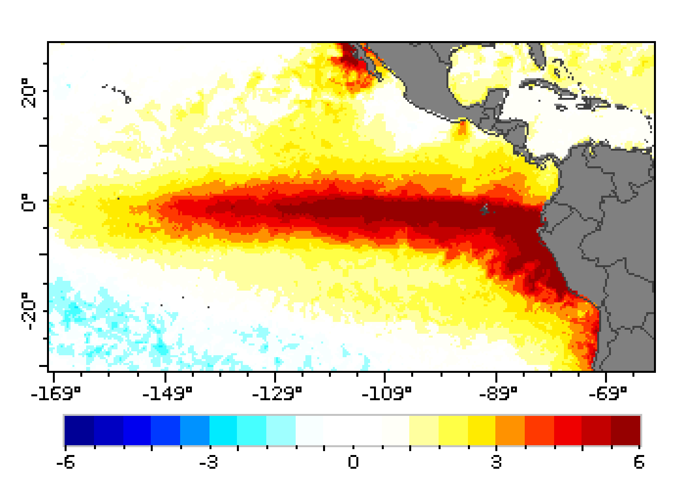
El Niño is an abnormal warming of the Pacific Ocean along the central and eastern equator. It alters atmospheric circulation and, with it, rainfall patterns in many parts of the world.[2]
In the sea surface temperature anomaly map of November 10, 2026, red shows water warmer than average. The strongest band lies along the equatorial Pacific and off the coasts of Peru and Ecuador.[2]
What INMET forecasts
In Bulletin No. 5 of the El Niño Panel, published on October 29, 2026, INMET says there is a high probability that the event reaches very strong intensity from November. The institute says the phenomenon is expected to persist and intensify through 2026.[1]
For November to January, INMET expects above-normal rain in the South and in parts of the Southeast and Centre-West. Temperatures should be above normal across almost the whole country, especially in the North. The exception is Rio Grande do Sul, where temperatures tend to be below normal.[1]
Too much rain and too little
Above-normal rain raises the risk of floods and waterlogging, especially in areas already vulnerable. Below-normal rain raises the risk of drought and wildfires, with effects on water supply and farming.[1]
The bulletin does not say which municipalities face the greatest risk. Its general warning is that the phenomenon increases the likelihood of hydrometeorological impacts in different parts of the country.[1]
What NOAA says
In an update dated November 12, NOAA kept its warning of a strong El Niño. According to press reports, the agency gives more than 79% odds of a strong to very strong event lasting into January to March 2027. The next update is expected on December 10.[2]
How to follow it, and what is still unknown
Long-range forecasts carry uncertainty. The final strength of the event and the rain in each city will only be clear as the months pass. Follow INMET's bulletins and your state's Civil Defence alerts, and keep your alert registration up to date.[1]
What you can do
- Register for your state's Civil Defence alert channels.[1]
- Follow INMET's El Niño Panel bulletins, which are updated monthly.[1]
What we don't know yet
- How far the event will peak, and when it will weaken.
- Which municipalities will get the heaviest rain or drought, at city-level precision.
- Which effects will appear in farming and food prices.
Sources
- INMET: Painel El Niño: Boletim de outubro é divulgado (accessed Nov 14, 2026)
- Unofficial Networks (on the NOAA update): New NOAA Forecast Gives 60% Chance Of Historic El Niño This Winter (accessed Nov 14, 2026)